National Geographic
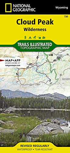
Cloud Peak Wilderness Map (National Geographic Trails Illustrated Map, 720)
Free shipping with 3 or more products in your cart
Payflex: Pay in 4 interest-free payments of R215.00. Read the FAQ
R 860
In stock
Duties, insurance and VAT included
Delivered in 10–20 working days —
Free shipping with 3 or more products in your cart
Secure checkout
Your payment is fully protected
Duties & VAT included
No surprise charges at the door
Tracked delivery
Track your order end to end
Returns support
30-day return window
Description
• Waterproof • Tear-Resistant • Topographic Map
Coverage includes Bighorn National Forest, Highland Park, Meadowlark Lake, Kearny Lake Reservoir, Coffeen Park. Includes UTM grids for use with your GPS unit.
Coverage includes Bighorn National Forest, Highland Park, Meadowlark Lake, Kearny Lake Reservoir, Coffeen Park. Includes UTM grids for use with your GPS unit.
- Folded Size = 4.25 x 9.25
- Sheet Size = 37.75 x 25.5
- Scale = 1:45,000
Technical Specifications
Manufacturer
Natl Geographic Society Maps
Height
10.2 cm
Length
22.4 cm
Width
1 cm
Weight
0.09 kg
Shipping & Delivery
Your order is shipped from the USA and delivered to your door in South Africa in 10–20 working days. All items are fully tracked.
Returns & Exchanges
We offer a 30-day return window. If something isn't right, contact our support team and we'll make it right.