

National Geographic Colorado Wall Map (40.5 x 30.25 in) (National Geographic Reference Map)
Product Description
National Geographic Colorado Wall Map (40.5 x 30.25 in) (National Geographic Reference Map)
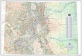
The spectacular topography of the Centennial State is expertly rendered on National Geographic's wall map of Colorado. Part of the growing series of State Wall Maps, this map depicts Colorado's diverse terrain and vegetation in remarkable detail. Mountain ranges, prominent peaks, major lakes, rivers, and reservoirs, and other geographic features are highlighted. In addition to hundreds of place names, this map includes the precise locations of cities, major roadways and railways, airports, military installations, federal and state parks, and protected areas. Prominent recreation features such as the Colorado Trail, Continental Divide Trail, and ski areas are also noted. This striking map would be an attractive addition to any study or office.
The map is packaged in a two inch diamater clear plastic tube. The tube has a decorative label showing a thumbnail of the map with dimensions and other pertinent information.
- Map Scale = 1:705,645
- Sheet Size = 40.5" x 30.25"
Technical Specifications
You might also like

Colorado Fourteeners Poster

DeLorme® Colorado Atlas & Gazetteer (Delorme Atlas & Gazetteer)
The Hiker's Map of Colorado - Wall Poster Map, by Outdoor Trail Maps LLC

Colorado Benchmark Road & Recreation Atlas
Colorado Recreation Map

Multi-Color Push Pins Map Tacks,1/8 inch Round Head with Stainless Point, in reconfigurable Container for Bulletin Board, Fabric Marking, map pins (15 Assorted Colors)

Hubbard Scientific Raised Relief Map 950 Colorado State Map

National Geographic: California Wall Map (33.5 x 40.5 inches) (National Geographic Reference Map)

National Geographic: United States Classic Wall Map (43.5 x 30.5 inches) (National Geographic Reference Map)