

Garmin BlueChart® g2 Vision® HD - VUS011R - Southwest Florida - microSD /SD
Product ID: B008S5RYLW
Condition: New
R 13,434
includes Duties & VAT
Delivery: 10-20 working days
Ships from USA warehouse.
Secure Transaction
VISA
Mastercard
payflex
ozow
Product Description
Garmin BlueChart® g2 Vision® HD - VUS011R - Southwest Florida - microSD /SD
- This chart is NOT compatible with GPSMAP 722sx, 7612xsv, 7610xsv, 922xs, Echomap Plus series or units with the latest update software/firmware
BlueChart g2 Vision HD - VUS011R - Southwest Florida - microSD/SD
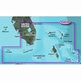
Coverage:
Crystal River through Key Largo, including Tampa Bay, Ft. Myers, Lake Okeechobee, Florida Bay, Key West, and the Dry Tortugas.
Premium Mapping and Graphics Capabilities
Based on the standard BlueChart g2 HD features, BlueChart g2 Vision HD provides premium mapping and graphics capabilities. Plug a BlueChart g2 Vision HD card into your compatible chartplotter's microSD/SD card slot to tremendously expand its mapping capabilities.
BlueChart g2 Vision HD is our premium marine cartography for use with Garmin chartplotters. It includes all the features of BlueChart g2 HD charts and adds Garmin exclusive Auto Guidance 3.0. Garmin Auto Guidance 3.0 technology quickly searches relevant charts to suggest a course according to your boat's dimensions and creates a visual path that seeks to avoid low bridges, shallow water and other charted obstructions. With version 3.0, Auto Guidance can guide the user and in and out of more places more effectively, including entering and exiting marin
Coverage:
Crystal River through Key Largo, including Tampa Bay, Ft. Myers, Lake Okeechobee, Florida Bay, Key West, and the Dry Tortugas.
Premium Mapping and Graphics Capabilities
- Detailed nautical charts, in vector object oriented format, derived from government charts and private sources to provide port plans, depth contours, navigational aids, and tides and currents in a seamless chart presentation
- Shaded depth contours and intertidal zones with spot soundings
- Aerial photos of ports, marinas, bridges and navigational landmarks and realistic "view from space" high-resolution satellite imagery
- Up to 1-foot HD contours provide a more accurate depiction of bottom structure for improved fishing charts and navigation in swamps, canals, marinas and port plans
- Garmin Auto Guidance 3.0 technology is now capable of providing routing guidance¹ to virtually any accessible destination on the water
- Worldwide coverage available in regionalized cuts
Based on the standard BlueChart g2 HD features, BlueChart g2 Vision HD provides premium mapping and graphics capabilities. Plug a BlueChart g2 Vision HD card into your compatible chartplotter's microSD/SD card slot to tremendously expand its mapping capabilities.
BlueChart g2 Vision HD is our premium marine cartography for use with Garmin chartplotters. It includes all the features of BlueChart g2 HD charts and adds Garmin exclusive Auto Guidance 3.0. Garmin Auto Guidance 3.0 technology quickly searches relevant charts to suggest a course according to your boat's dimensions and creates a visual path that seeks to avoid low bridges, shallow water and other charted obstructions. With version 3.0, Auto Guidance can guide the user and in and out of more places more effectively, including entering and exiting marin
Technical Specifications
Country
USA
Brand
Garmin
Manufacturer
Garmin
Binding
Misc.
ItemPartNumber
010-C0712-00
Model
Garmin
UPCs
753759068929
EANs
0753759068929
You might also like

Goplus 4 Ribbed Marine Boat Fender Vinyl Bumper Dock Shield Durable (Blue, 6.5" X 23")
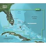
GARMIN VUS010R SOUTHEAST FLORIDA BLUECHART G2 VISION
New-GARMIN VUS513L JACKSONVILLE TO BAHAMAS BLUECHART G2 VISION - 30408

Star brite Non-Skid Deck Cleaner with PTEF 1 Gallon

SeaSense Double Braid Nylon Dockline, 3/8-Inch X 20-Foot, Black

Booms Fishing X1 Aluminum Fishing Pliers Hook Remover Braid Line Cutting and Split Ring with Coiled Lanyard and Sheath

3M Marine Adhesive/Sealant Fast Cure 4200, 05260, White, 3 oz

Star brite Instant Hull Cleaner 32 oz

BoatMates Cockpit Organizer, White