

Humminbird 600033-1 AutoChart Zero Line North America Map SD Card,Beige
Product Description
Humminbird 600033-1 AutoChart Zero Line North America Map SD Card,Beige
- Foundation for Custom Mapping: Use this 32 GB card with AutoChart or AutoChart Live to create your own detailed contour maps; Includes 16 GB of free space to maintain your custom maps
- Extensive Shoreline Data: Pre-loaded with Zero Lines for over 140,000 named water bodies and over 1.75 million unnamed water bodies in the U.S. and over 96,000 named water bodies and over 3.85 million unnamed water bodies in Canada
- Record Directly to the Card: Save AutoChart Live data including depth contours, bottom hardness, and vegetation with compatible Humminbird models
- Share Your Maps: Use as an extra card to view your custom-made maps on multiple compatible Humminbird fish finders
- Broad Compabitlity: Zero Lines Card is optional for select APEX, SOLIX, ONIX, ION, HELIX, 1100, 900, 800, and 600 Series models; Compatibility subject to change without notice
""The Humminbird LakeMaster MidSouth States Edition, Version 2 Map Card features many FRESHWATER lakes in Texas, Oklahoma, Arkansas, Louisiana and Mississippi on one SD map card. Also Version 2 includes detailed coastal shoreline from Texas to Mississippi that allows anglers with i-Pilot Link to "follow the shoreline" at a specified offset for hands free fishing in shallow coastal areas. Great for fishing around mangroves, islands and inter coastal waterway shorelines. The MidSouth States Edition map card added over 80 high definition lakes to the Version 2 product and features over 240 total lakes with contours, of which 161 are now High Definition lakes including these highly requested water bodies: - Arkabutla, MS - Sardis, MS - Sardis, OK - Fort Gibson, OK - McGee Creek, OK - Carl Albert, OK - Ponca, OK - Travis, TX - Lake Houston, TX"".
Technical Specifications
You might also like

Humminbird 720074-1 AS EC QDE 700 Series Ethernet Adapter Cable
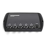
Humminbird 408450-1 5 Port Ethernet Switch

RAM-D-202-25-C-202U Flat Surface Short Arm Mount fits Humminbird Helix 9 10 & 12

Humminbird 720073-6 Humminbird 720073-6 AS EC 5E Ethernet Cable, 5-Foot

Humminbird 780029-1 Helix 7 Series Unit Cover
Humminbird 720073-5 15 Foot Ethernet Cable
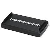
Humminbird 780036-1 Humminbird 780036-1 UC H7 PR Unit Cover for Helix 7 Fishfinder Models

MinnKota US2 Adaptor Cable for Humminbird 7 Pin
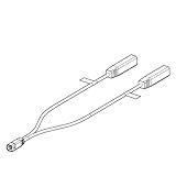
Humminbird 720101-1 Humminbird 720101-1 9 M SIDB Y 9-Pin Side Imaging Dual Beam Splitter Cable

RAM MOUNTS 1.5" Ball Mount for The Humminbird Helix 7 Only