
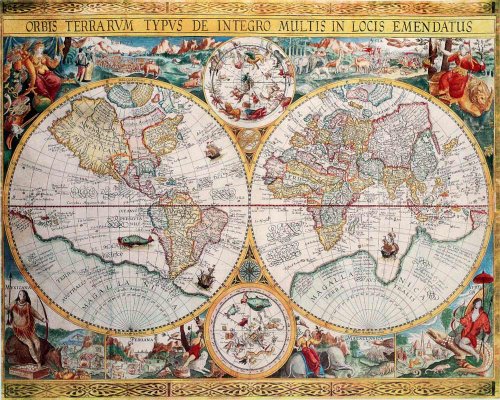
Map of the World (Orbis Terrarum) by Petrus Plancius 1594 - Art Poster Print (16x20)
Product Description
Map of the World (Orbis Terrarum) by Petrus Plancius 1594 - Art Poster Print (16x20)
- POSTER ONLY - POSTER SIZE - 20 x 16". High quality print on satin-finish paper
- UNFRAMED POSTER is a simple and bright way to express yourself and make your place special
- This POSTER is perfect for your home, office, place of business or an excellent gift idea for someone special. It is large enough to look great in any space
- SHIPS ROLLED within a sturdy cardboard mailing tube to minimize any damage and ensure safe delivery
- Beautiful colors and high quality reproduction will make a great addition to any decor
Petrus Plancius (1552 - May 15, 1622) was a Dutch astronomer, cartographer and clergyman. He studied theology in Germany and England. At the age of 24 he became a minister in the Dutch Reformed Church. Because of fear for religious prosecution by the Inquisition he fled from Brussels to Amsterdam after the city fell in Spanish hands in 1585. There he became interested in navigation and cartography and, being fortunate enough to have access to nautical charts recently brought from Portugal, he was soon recognized as an expert on the shipping routes to India. He was one of the founders of the Dutch East India Company for which he drew over 100 maps. Orbis Terrarum, created in 1594, holds the distinction of being the first world map to use a style of richly decorated border that would dominate world maps for decades to come. The elaborate borders were inspired by drawings in the works of Theodore de Bry published a few years earlier and established a pattern of cartographical decoration that lasted over a century. The map also has great importance geographically, particularly in the mapping of the Arctic and the Far East. The map contains a marvelous attempt at a North-West Passage, and Plancius himself instigated the three voyages of Willem Barents (1594-1597) into the area. He used this map to give cartographic encouragement to the Dutch crews by turning Novaya Zemlya into an island with open sea between it and the Arctic. A sprinkling of English names in the Canadian Arctic appear as a result of Frobisher and Davis's explorations in search of the passage in 1576-1587. The map is also a landmark in the mapping of Asia and Japan. Plancius was one of the first Europeans able to penetrate the wall of secrecy surrounding the manuscript portolan maps produced by Spain & Portugal.
Technical Specifications
You might also like

World Map Antique Vintage Old Style Decorative Educational Poster Print, 16x20 Unframed

17th Century World Map Poster Print

Classical World Map Poster 36 x 24in

4" Sundial Compass - Solid Brass Sun Dial
Antiqued Brass Poem Compass With Leather Case

Vintage Old World Map Poster Print Art 1733 Nautical Sailing Ship Map Home Wall Decor

ITALIAN Old World Exploration Angel & Cherub MAP by Paolo Forlani circa 1565 - measures 24" high x 36" wide (610mm high x 915mm wide)

World Map (Antique) Art 24x36 Poster

Ortelius World Map 1570 - NEW Classroom Social Studies Poster

Map Of The World Mercators Projection A J Johnson 1860 Vintage Historical Cartographic Print Poster 18x12