
National Geographic: Iran Classic Wall Map (30.25 x 23.5 inches) (National Geographic Reference Map)
Product Description
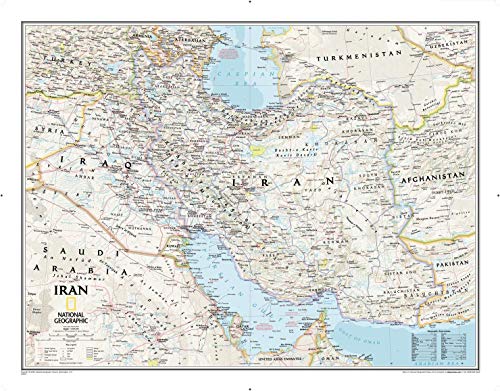
National Geographic: Iran Classic Wall Map (30.25 x 23.5 inches) (National Geographic Reference Map)
National Geographic€s political map of Iran is one of the most authoritative and detailed maps available for this country that is heir to one of the world's oldest civilizations. This Classic style wall map features a bright color palette and stunning shaded relief that has been a hallmark of National Geographic maps for over 75 years. Thousands of place names, accurate political boundaries, national parks, mountain peaks and passes, swamps, deserts, lava fields, dry lakes and major infrastructure networks such as highways and roads, airports, railroads, oil fields and pipelines, and canals are detailed. Significant bodies of water, such as the Persian Gulf, Caspian Sea and Strait of Hormuz are shown with coastal bathymetry using depth curves and soundings. Coverage also includes Iraq, Qatar, Kuwait, Bahrain and parts of Syria. Saudi Arabia, UAE, Oman, Pakistan, Afghanistan, Uzbekistan, Turkmenistan, Azerbaijan and Armenia.
The map is packaged in a two inch diamater clear plastic tube. The tube has a decorative label showing a thumbnail of the map with dimensions and other pertinent information.
- Map Scale = 1:3,696,000
- Sheet Size = 30.25" x 23.5"
Technical Specifications
You might also like

NICHE 428 Pitch 13 Tooth Front Drive Sprocket for Honda CRF125F SporTrax TRX90 23801-HF7-000

Kenmore Elite White 5.2 Cubic Feet Front-Load Washer with Steam Treat, Accela Wash, and Includes Delivery and Hookup

Guida ai modelli di scarpe da uomo: I 7 modelli di scarpe che NON possono mancare nel tuo guardaroba (Eleganza Maschile) (Italian Edition)

Tommy Hilfiger Baby-Boys Infant Short Sleeve Ivy Bodysuit, Minty Fresh, 6 Months

Trapped: The Iron Druid Chronicles, Book 5
Gammaton Reservoir Lake Safety Book: The Essential Lake Safety Guide For Children

Ultimate Barbecue and Grilling for Beginners & Slow Cooking Guide for Beginners (Cooking Box Set)

Galletue Lake Safety Book: The Essential Lake Safety Guide For Children