

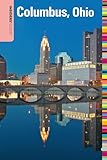
Rand McNally Columbus, Ohio Street Map
Product Description
Rand McNally Columbus, Ohio Street Map
- Regularly updated
- Full-color maps
- Clearly labeled Interstate, U.S., state, and county highways
- Indications of parks, points of interest, airports, county boundaries, schools, shopping malls, downtown & vicinity maps
- Easy-to-use legend
- Detailed & full street index
- Convenient folded size
- Copyright 2020
Rand McNally's folded map for Columbus is a must-have for anyone traveling in and around this part of Ohio, offering unbeatable accuracy and reliability at a great price. Our trusted cartography shows all Interstate, U.S., state, and county highways, along with clearly indicated parks, points of interest, airports, county boundaries, and streets. The easy-to-use legend and detailed index make for quick and easy location of destinations. You'll see why Rand McNally folded maps have been the trusted standard for years.
Regularly updated
Full-color maps
Clearly labeled Interstate, U.S., state, and county highways
Indications of parks, points of interest, airports, county boundaries, schools, shopping malls, downtown & vicinity maps
Easy-to-use legend
Detailed & full street index
Convenient folded size
© 2014
Regularly updated
Full-color maps
Clearly labeled Interstate, U.S., state, and county highways
Indications of parks, points of interest, airports, county boundaries, schools, shopping malls, downtown & vicinity maps
Easy-to-use legend
Detailed & full street index
Convenient folded size
© 2014
Technical Specifications
You might also like

Rand McNally Easy To Read: Ohio State Map
Insiders' Guide® to Columbus, Ohio (Insiders' Guide Series)

Rand McNally Easy To Fold: Idaho (Laminated) (Rand McNally Easyfinder)

Rand McNally Cleveland, Cuyahoga County Street Map

Rand McNally 8th Edition Columbus street guide

Ohio Atlas & Gazetteer
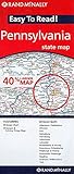
Rand Mcnally Easy To Read: Pennsylvania State Map

Rand McNally: Columbus/Cincinnati, Ohio Regional Map (Rand McNally Columbus/Cincinnati Regional Maps)

Day Trips® from Columbus: Getaway Ideas For The Local Traveler (Day Trips Series)

Rand Mcnally Folded Map: Pittsburgh Street Map (Rand McNally Pittsburgh Street Guide)